Geography Grade 12 | Paper 1 | Essential Revision 2
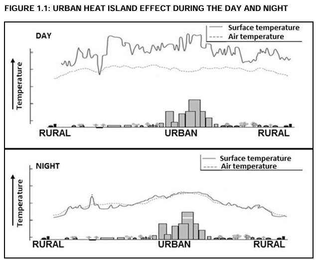
The FIGURE below shows an urban heat island effect during the day and night. Match the descriptions below with the diagrams showing DAY and NIGHT.
Question
Reflects the highest temperatures in an urban heat island
Answer: Day
During the day, buildings, roads, and other urban surfaces absorb and retain more solar radiation, which results in higher surface and air temperatures in urban areas compared to rural ones.
Question
Pollution is dispersed over a greater area
Answer: Day
Solar heating causes rising warm air currents, which help to lift and disperse pollutants over a wider area during the day.
Question
Artificial heat generation is at its lowest
Answer: Night
At night, many industries shut down, traffic is reduced, and air conditioning systems operate less frequently, lowering artificial heat production.
Question
Increased human discomfort due to higher temperature
Answer: Day
High daytime temperatures, especially in urban areas, can lead to heat stress and dehydration, increasing discomfort for city dwellers.
Question
Greater difference between air and surface temperatures
Answer: Day
Surfaces like asphalt and concrete heat up much faster than the air during the day, leading to a noticeable temperature difference between the ground and surrounding atmosphere.
Question
Limited multiple reflection of heat
Answer: Night
At night, there is no solar radiation, so the only heat present is re-radiated from surfaces, leading to fewer instances of heat being reflected multiple times between surfaces.
Question
Fewer human activities generating heat
Answer: Night
Most commercial and industrial activities decrease significantly at night, which means less anthropogenic heat is being produced.
A. Ungraded profile, B. Temporary base level, C. Base level of erosion, D. Permanent base level, E. Graded river, F. Source, G. Longitudinal profile, H. Cross profile, I. Mouth
Choose a term from the list above that matches a description below
Question
Equilibrium between the rate of erosion and rate of deposition
Answer: E – Graded river
A graded river is in a state of balance where the rate of erosion is equal to the rate of deposition, creating a smooth, adjusted river profile.
Question
Shows a view of a river from bank to bank
Answer: H – Cross profile
A cross profile illustrates a horizontal section across the river channel and its banks, showing the river’s shape and features from side to side.
Question
Shows a side view of the river from the source to the mouth
Answer: G – Longitudinal profile
A longitudinal profile presents the river’s gradient and elevation change from its origin to where it flows into a sea or lake.
Question
Point where a river enters the sea
Answer: I – Mouth
The mouth is where a river discharges its water into a larger body such as a sea or ocean, marking the end of its course.
Question
A river that has obstructions along its course
Answer: A – Ungraded profile
An ungraded profile is characterized by irregularities like rapids or waterfalls, indicating uneven erosion due to changes in gradient or rock type.
Question
A dam is an example of this base level of erosion
Answer: B – Temporary base level
A dam acts as a temporary base level by interrupting the river’s natural flow and preventing further downward erosion beyond its barrier.
Question
The lowest level to which a river can erode
Answer: D – Permanent base level
The permanent base level, often at sea level, is the ultimate depth a river can erode its bed, as it cannot cut below this point.
Question
The point where a river originates
Answer: F – Source
The source is the starting point of a river, typically found in highlands or mountainous regions, where precipitation accumulates.